The Tri-Valley’s open roads and rolling hills make it one of the best places in California for adult road cycling – whether you’re an expert or you’re just shaking off your training wheels. We’ve plotted out some of the best cycling routes and some pit stops on the way whether you’re training for a big race, or just want to enjoy the views.
Danville’s wide roads feature designated bicycle lanes for their vast cyclist community, making this a safe and easy ride for beginners. If you’d like to explore, Sycamore Valley Road also boasts side bike trails that won’t take you too far off of your path. Start by parking at Danville’s Park & Ride station and heading east down Sycamore Valley Rd., which eventually turns into Camino Tassajara. At the end of that road, feel free to park at Blackhawk Plaza to catch a movie, hang out in their outdoor lounge areas, or grab some lunch! When you’re ready for the ride back, head west back the way you came. If you’d like to extend your ride, go past the Park & Ride and turn right onto San Ramon Valley Blvd. Ride down that road for about half a mile, then park your bike at the San Ramon Valley Blvd. Rest Area next to Jiffy Lube, and take a stroll around Downtown Danville. Grab some ice cream at Lottie’s Creamery or a burger at Norm’s Place. When you’re ready to head back to the Park & Ride, hop on the Iron Horse Trail until you arrive back at the Park & Ride on Sycamore Valley Rd.
This bike loop doubles as a self-guided wine tour throughout Livermore Valley Wine Country! Riders should be cautious that drinking alcohol and biking can be dangerous – so make sure to stay hydrated, eat food, and pace yourselves. Start at Campo di Bocce and enjoy the scenic vineyard surroundings heading southeast on E. Vineyard Avenue. Turn left on Vallecitos Rd. and make a quick right to stay on E. Vineyard Avenue, and continue for 3/4 of a mile and turn right onto Kalthoff Common. Follow this road around the bend to your first stop to the left, Tenuta Vineyards (Mon-Thurs tastings are by appointment only). When you’ve finished there, continue your ride down Kalthoff Common for another 3/4 of a mile, then make a right onto Vallecitos Road. Continue for less than a mile and arrive at your next stop on your left, Fenestra Winery (tastings on Fri-Sun only). Finish off your ride continuing on Vallecitos Rd., making a right back onto E. Vineyard Avenue until you arrive back at Campo di Bocce. Feel free to enjoy lunch or dinner while challenging your ride mates to a game of bocce!
For those who want to stay away from cars and traffic but still want a challenging ride, hop on the Iron Horse Trail for a quiet ride through the Tri-Valley. Start by parking at Dublin BART, which offers easy access to the Iron Horse Trail. Follow the trail for 9.5 miles to the San Ramon Valley Blvd. Rest Area for easy bike parking in the center of Downtown Danville. Stop there for a coffee at Medleno Coffee Shop & Roastery or a quick bite to eat at Danville Harvest, a farm-to-table restaurant that features locally sourced ingredients. If you need any fast bike repairs or cycling accessories, visit California Peddler, a staple bike shop for local cyclists.
This relatively flat route includes an optional stop at one of Pleasanton’s wineries for a quick tasting or a bite to eat. Start at Shadow Cliffs Recreation Area for pain-free parking, head east on the Iron Horse Trail towards Isabel Avenue, turn right on Isabel Avenue and continue on that road for approximately 1.5 miles before turning right again onto Vineyard Avenue. Feel free to make the first stop at Ruby Hill Winery, or continue a bit further down the road at Rubino Estates Winery. Both wineries feature authentic Italian delis, bocce courts, and picnicking areas. After your stop, continue down Vineyard Avenue for less than two miles until Bernal Ave. Make a right on Bernal Avenue, get ready for a quick turn back onto Stanely Blvd. Follow Stanley until you arrive back at Shadow Cliffs Recreation Area.
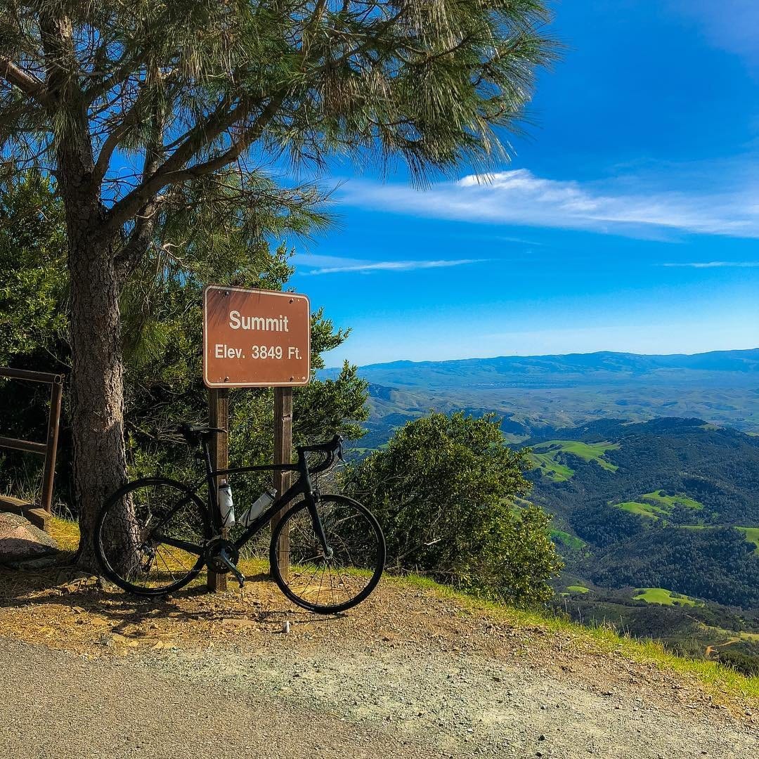
The Mt. Diablo route is known near and far by cyclists as one of the hardest rides in the area. For those cyclists wanting a true challenge, this 3,340 ft. climb is sure to deliver. Park your cars at Athenian School and follow Mount Diablo Scenic Road for 1 mile until the road turns into S. Gate Rd., continue climbing up this windy road for nearly 6 miles until you arrive at the Junction Ranger Station. Follow the Summit Road for another 4.5 miles to your midway point, the Mt. Diablo Summit Museum. On clear days, you’re able to see for miles at the top of Mt. Diablo – so be sure to take in the views! Once you’re ready to get back on the saddle, descend the mountain the same way you came up. Mt. Diablo is a popular tourist spot on the weekends, so beware of cars and foot traffic on your way down.
The House of Pain loop has truly earned its name within cyclist communities. Saturday morning cyclists have been known to make this ride in groups as big as 50 people in the early morning, taking over the rural roads between Danville and Livermore. Most of these riders will park their cars at Peets Coffee in Downtown Danville to start their 40-mile trek, a great place to fuel up on caffeine to help power through the rest of their day. From there, ride from Downtown Danville to the end of Sycamore Valley Road and Camino Tassajara, turning left at Highland Rd into Livermore’s backroads. Follow this scenic road of rolling hills and local ranches for 3 miles, then turn right onto Manning Road. After riding for 3 miles, make the 90-degree angle right turn onto N. Livermore Avenue. Continue down this road for a little over 4 miles until Portola Avenue which turns into Airway Blvd. Take Airway Blvd over Interstate 580 and make a right onto N. Canyon Parkway for a short while until turning left onto Collier Canyon Rd. Continue this leg of the ride for nearly 5.5 miles until you close the loop arriving back at Highland Rd. Make a left onto Highland Rd., a right onto Camino Tassajara, and follow that straightaway back to your starting point in Downtown Danville. This ride is not only challenging, but offers some of the best views of the Tri-Valley.